There Is No Someday |
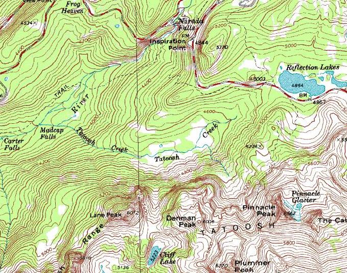 After eyeing the late April weather predictions of snow on Saturday but sun on Sunday, we decided to set out for Lovers Lane on Lane Peak at Mt. Rainier National Park on Sunday, April 25th, 2010. We arrived at the Narada Falls parking lot geared up and began climbing the hill at the East end of the parking lot. We opted to follow the trail through the trees to a point where the slope up to the road was shorter and less steep. The hill looked like it was probably okay, however with several new inches of snow from the day before and disrupted signs in the snow we opted for the safer approach. The snow on the hill we climbed to the road was solid and the weather conditions were cooler than predicted, looking like the snow from yesterday would not be a deterrent for the hike. When we reached the road we realized what had caused the snow disruptions – the park service had plowed the road leading to Reflection Lake. Though the road was not yet open it was well cleared.  View of Lover’s Lane from Narada Falls Parking Lot – Lover’s Lane in Red After a quick jaunt down the road to where it bends towards reflection lake, we crested over the snow pile and started down to the South point for Lane Peak. The terrain in this area constantly pushes you toward the East, up and toward the Pinnacle Peak area. Descending the hill be sure to push to the right, further than you think necessary. At the bottom of the hill is the river bed winding its way downhill. Finding a snow bridge in good condition took a bit of scouting, but several were still holding form. After crossing the creek we headed West (as we hadn’t pointed quite far enough and ended up by Denman Peak). About a quarter of a mile and we were at the base of Lane Peak. We began angling up and to the right aiming for a clump of trees to drop our snow shoes that we would retrieve on our way back down.  Lover’s Lane After dropping our snow shoes, we slogged through the soft lower angle snow to the base of the couloir. There was a first break in the trees headed up, however it looked like this lead to the far left side instead of up the rock band. Instead we traversed right maybe 20-30 ft around a protruding rock band and found what appeared to be the right route – leading up and to the right. The zipper would be the next couloir over and it would lead to the left intersecting with Lover’s Lane high on the mountain.  First Band and Anchor Tree We headed up the lower, less angle portion with crampons but no rope with Steve in the lead breaking the soft trail. This is likely an area described as the first rock/ice band early in Winter before the snow fills it in. Now it was snow all the way up the route. We found a good anchor tree off left, and climbed up and over to the tree. We set up an anchor and I (Melissa) with a brave – “I’d like to Give this a Go” started up the middle left section of the couloir. Our plan was to simul-climb as long as we felt comfortable on about 100 ft of rope and pitch it out if need be. I found a nice tree or two along the route, good placements for pickets (we carried four) and a few rock placements once I reached the rock band. The rock placements were the most questionable, and the bottom portion was challenging to find anything. Higher up I used a Metolius #1 and #2 TCU, and a 0.5” cam.  Looking up Lover’s Lane from our anchor point Eventually, running low on gear/slings I built an anchor in a couple of crack systems using a nut, link cam (~1.25” crack), and ice axe. The first section was fun, ever steepening and invigorating (I had forgotten how much Easier it is to follow second behind Steve’s well-kicked steps). After Steve came up we decided to continue on up the chute – aiming to do a bit of mixed climbing on the right side and exit near the top of the chute but on the rock ridge. Part way up the steep slope I headed over to what looked like a good bit of mixed section. I went up about 10-15 feet to a tree before deciding to traverse back to the main chute. The rock had too much vegetation and not enough snow coverage. It was pretty sketchy and didn’t flow very well. After regaining the slope I continued up to a nice set of three trees at the top of the ridge and set an anchor.  The top portion of the Chute – headed to a tree anchor, view from the far right side Once Steve reached the anchor, we decided he should go on up the last few feet and scout for the rappel tree that would take us down to the Zipper. Steve scouted the ridge and determined that there was a pretty questionable looking cornice between us and the rappel tree. Also, we had brought a 60 m rope and a 30 m extra rappel line. However, looking down into the Zipper it looked like it would take a full two ropes to make it down to the bottom of the chute. It looked like there was a potential to go up and to the left and find a rappel from the ridge that would drop us onto the East side onto easy terrain. Steve led up about 100 ft of steep mixed terrain to a good anchor tree and brought me up. I swung to the lead and went up the about 20-30 ft to see what was at the top of the ridge. Unfortunately it looked like the ridge continued to go up and there was no good rappel spot in the immediate area. We could continue on up the ridge but the snow was much softer here and wind deposited. Trying to step up the snow tended to collapse underfoot. At this point we decided the easiest descent would be to rappel Lover’s Lane and downclimb as necessary. I down-climbed back to Steve and we rappelled back to the three trees at the top of the ridge. From there we rappelled down to another tree on the climber’s right side of the col, then down to the rock band on climber’s left where Steve set a piton for another anchor. From the piton we rappelled to a tree and one last rappel took us onto less steep slopes (almost back to our first tree anchor). From here we down-climbed another 100-200 ft and then glissaded as far as possible back to the snow shoes. A last bit of slogging in the softened snow got us to back to the snowshoes and we grabbed some food and started the hike out. After re-crossing the creek the hike back up-hill to the ridge seemed a bit harder than it should. But, before long we were on the road and headed back towards the car. One last down-hill and we were back at the Narada Falls parking lot, tired but totally jazzed. It was a really fun climb, with beautiful views of Mt. Rainier, cliff bands, rock and snow.  Rappeling the route. Steve is about where he put in a Bugaboo piton |

|
| steve@thereisnosomeday.com |